
Fast-growing satellite networks bring unprecedented data and connectivity to ag production.
Agriculture, Ag Tech June 01, 2024
A View from Above
The stars align for satellites to open a world of opportunity.
by Martha Mintz
TEN...NINE...EIGHT...a countdown is always thrilling. It leads to an explosion of activity. Agriculture has a rocket on the pad and a countdown is well underway to launching a new era of satellite-driven, functional, system-of-systems digital ag advancements.
Satellites have long delivered beautiful maps and interesting information, but the data hasn't always been overly practical or useful for farmers or scientists, says Kaiyu Guan, University of Illinois earth systems scientist.
That's changing. "A beautiful map isn't useful," says Guan, the chief scientist of the NASA Acres Consortium (NASA's flagship program for domestic agriculture).
"Progress in the recent decade is taking satellite data beyond to provide important variables people can use to actually optimize the management of their land for productivity and environmental outcomes."
More progress can be expected in the coming decade. Continuing advancements are being fueled by an alignment of favorable circumstances, says Alyssa Whitcraft, University of Maryland research professor and executive director of NASA Acres and NASA Harvest Sustainable and Regenerative Agriculture (SARA) initiative. They include:
—Free/open data from NASA and worldwide space agencies.
—Advances in computation capabilities including cloud computing, AI, and machine learning.
—Frequent commercial launches putting into orbit satellites with increasingly advanced imaging and communications capabilities.
—Implementation of policies freeing public and private sectors to collaborate more efficiently.

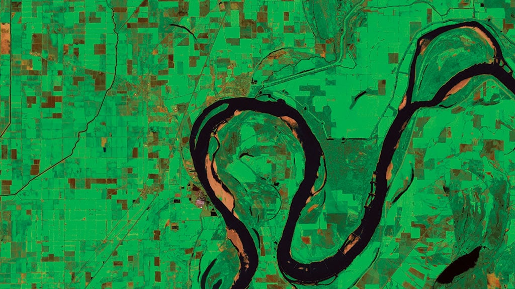
Above. Fluid collaboration between government, university, and private sectors is helping advance digital agriculture, Alyssa Whitcraft says. While NASA focuses on innovation and development, others turn information into services. (Satellite image provided by Nicole Pepper, using Copernicus Sentinel 2 data from 2023 provided by the European Space Agency.)
SEVEN...SIX...FIVE... "It's an exciting time," says Whitcraft.
Downloading raw satellite data as a PhD student in 2010 took monumental effort for Whitcraft. It meant months of running scripts every night just to get her hands on the 30-plus terabytes of data needed for her work. It was time consuming and expensive...but the data was available.
In 2008 the United States Geological Survey (USGS), NASA, and Digital Object Identifiers, enacted a free-and-open data policy. For the first time the public had access to Landsat data.
"Suddenly the data is freely and openly accessible. That's the first step for successful innovation," Whitcraft says. Next is the ability to quickly and affordably process the daunting piles of data.
Cloud technology solves this problem. It provides on-demand, pay-as-you-go access to extremely powerful computer processing. This makes retrieving and running analysis on Landsat and other available data fast, easy, and affordable.
Open-source data from Landsat and other satellites was used to develop cloud-based analysis platforms like Google Earth, USGS EarthExplorer, and EOSDA Crop Monitoring. These platforms help put functional data in front of more people.
"The bar isn't set as high for the data to be useful. With some training grad students—high school students even—can start using satellite data," Guan says.
Programs like NASA Applied Remote Sensing Training (ARSET) offer free education on accessing and using satellite data for agricultural purposes.
"Rather than bringing raw data to the people, [technology and access] brings people to the data," Whitcraft says. More people working the problems likely means faster advancement.
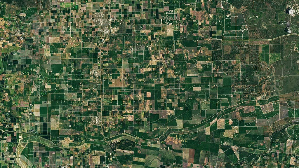
Above. From crop photosynthesis and nitrogen to evaluating biomass of cover crops, Kaiyu Guan is focused on identifying ways satellite data can provide farmers with functional, actionable information. Above. Crop scouting is time consuming. Satellites provide near-continual observation to more efficiently collect critical data. (NASA Earth Observatory image by Lauren Dauphin, using Landsat data from the U.S. Geological Survey and cropland data from USDA NASS.)
FOUR...THREE...TWO... January 3, 2023, Yevhenii Marchenko, EOS Data Analytics sales lead, watched online as SpaceX's Falcon9 rocket carried EOS SAT-1—the first commercial agri-focused satellite for the company—into low Earth orbit.
The satellite's imaging technology captures 11 spectral bands (ranges of light wavelengths).
"Each crop has a unique reflective signature," Marchenko says. More spectral bands bring more insight. "Machine learning can help process this data and translate it into vegetation indexes for crop monitoring."
The ability to remotely identify crops, including cover crops, adds another data point for modeling complex ag systems.
"One of the biggest benefits of satellites is frequency," Whitcraft says. "They can capture images weekly, even daily, tracking crop change in near real time."
Growing communications satellite networks are set to ensure full-farm connectivity for fluid, efficient data collection and transfer. John Deere linked with SpaceX Starlink to this end.
"This is game changing not only for areas of limited connectivity in the U.S., but globally," says Mike Kool, John Deere Intelligent Solutions Group.
"Fully connected fleets can capture 100% of critical data 100% of the time allowing for the most efficient, productive, and sustainable management."
Continuously collected data is piling on an already robust archive. Within that data are the keys to understanding and managing for more variables in complex farm systems. There's potential for farmers to gain a deeper understanding of the effects of their long-term practices or even quantify the environmental benefits of their practices for marketing.
"There's a deep time record with lots of coverage we can use to unlock those questions," Whitcraft says. It's simply a matter of time...ONE...LAUNCH! ‡
Read More
AGRICULTURE, LIVESTOCK/POULTRY
More than Food
From farm to table, this ranch family is improving lives along the way.